Saturday, 31 August 2019

Tall Ships 2019

St. Lawrence River Brockville

Brockville waterfront

Our track


This Labour-day weekend the Tall Ships are once again visiting Brockville to the delight of hundreds of spectators lining the waterfront and Blockhouse  island.  A friend and I will be paddling out to meet the parade and get up close to these magnificent sailing ships.    Some areas downtown are closed to traffic and with so many visitors parking it's difficult to obtain close to the water so I am getting my wife to drop me at our put-in on Henry St.  We are early with time to kill before the parade so opt to paddle east towards the 3 sisters islands where we hear that on a previous occasion the tall ships mustered.


Blockhouse spectators
Henry St. put-in


It is a great day for this event but with the WSW 17km gusting to 26km winds it will be a struggle paddling back upstream.  As we pass the mooring for both the Pride of Baltimore and Bluenose II, Bluenose heads out towards mid-stream then turns upriver as does another tallship from the U.S. shoreline which suggests the start is going to be west of Brockville.

Baltimore mooring
Bluenose II


Turning around we paddle back upstream towards Brockville at a snail pace against the wind and current.   At Blockhouse island I stop and try to hold position as the first ship of the parade heads in our direction so here I will stay and try to get some decent images of them as they sail by.

Hopefully I have these in the right order, first up is Fair Jeanne a brigantine from Ottawa launched in 1980.

Fair Jeanne

Next up another vessel from Ottawa, STV Black Jack, brigantine built 1904 in Scotland (Yeah!).

Black Jack
And now one of the best known tallships Nova Scotia's schooner Bluenose II built in 1963.

Bluenose II

Then I believe HMCS Oriole was along next a ketch launched in 1921 but I failed to get an image as some sailboat butted in front spoiling my view so this image was captured by my wife from shore using my 18x zoom camera and catching me in the frame.

HMCS Oriole


An American ship the Pride of Baltimore II built 1988 as a reproduction of a Baltimore Clipper schooner circa 1812, home port Baltimore MD.

Pride of Baltimore II

Another replica from our early beginnings, but for the voyages of this ship we might not have been here today.   Christopher Columbus ship the NAO Santa Maria built 2018 by Spain.

NAO Santa Maria

From Kingston Ontario we have our very own STV St. Lawrence II built in 1953 in brigantine style.

STV St. Lawrence II

Last up we have what to me represents the epitome of the classic Tall Ship the Empire Sandy and I was amazed to learn she began life in 1943 as a deep sea tug and performed considerable war service during WW2 only being converted to a Tern schooner in the 1970's.

Empire Sandy

After the stars of the show passed came the locals, Coast Guard, fire tender, a variety of police vessels and of course my friend and I in our Small Ships😀


Happy Paddling
KayakJock


Wednesday, 14 August 2019

St Lawrence River - Prescott

Battle of the Windmill  & Fort Wellington


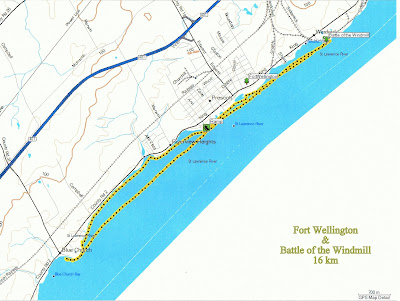
Today I'm heading out to view a couple of historic sites which can be seen from the water and in the case of the battle site we plan to stop and have an early lunch there after which we can do a bit more paddling upstream before returning to Prescott.  This will be a fairly short paddle as the places of interest to us are close by, downstream is the bridge to Ogdensburg USA and some industrial complexes so not too scenic.

Prescott public launch
Our launch is from the ramp in a very pleasant waterfront park with an adjacent beach in Prescott.  There is adequate free parking.   Heading downstream we go past the Prescott Coast Guard station and vessel "Griffon" tied up at the wharf.  She is equipped with a boom presumably for maintenance/placement of navigation buoys a number of which can be seen stacked on the wharf.

Coast Guard Stn.
CGS Griffon


Within minutes we are in front of Fort Wellington built by the British in defense of Upper Canada.   My Great-great grandfather's regiment the 79th reg. of foot, or Cameron Highlanders had a detachment here while they were on garrison duty at Fort Henry in the 1830's.   The fort is open to the public and has a small museum which has the hull of a British gunboat from that era and salvaged from the river.

Fort Wellington

Approximately 3.5 km from the put-in is the site of the Battle of the Windmill, a last attempt by some exiles with their American sympathisers to invade Canada in 1838.   I will reproduce below some images of the plaques which inform the visitor of this failed (thankfully!) attempt.

Battle site
Plaque


We park our kayaks in the reeds and secure to a tree before settling down for lunch at the picnic table on the rocky ledge just a few feet above the water with a magnificent view of the river and the seaway traffic which passes by.

Kayak mooring


Industrial Strength
This vessel registered in Liberia, is enroute to Duluth at the Western end of Lake Superior and is transporting wind turbines.


The story of the Battle of the Windmill

Looking back as we leave the Windmill behind the International bridge can be seen connecting Johnstown ON to Ogdensburg NY.

International Bridge
We retrace our course passing our put in and continue upstream following the Canadian shore.   We notice many docks and a few boathouses badly damaged or torn from their moorings and inquire of one of the residents as to the cause.  Turns out this is down to the high winds and flooding experienced on the St Lawrence upstream of the Cornwall dam, the same flooding I witnessed in the Admiralty islands off Gananoque about a month previous.   There is also a number of very attractive homes, one in particular caught my eye because of the attractive and unusual sculpture in their gardens.  My impression was of a  female in a flowing gown with arms outstretched, and perhaps a crown?  All down to the eye of the beholder!

Sculpture
Shortly after this we turn around and head back to our launch point to take out and head home after a very pleasant and relaxing paddle and a little more appreciative of this great country we live in and those who protected it in the past.

Homeward bound


Happy paddling
from
KayakJock


Monday, 5 August 2019

Rideau Canal - A Day's Locking

Merrickville to Muldoon Road


Merrickville-Muldoon Rd 19km

For those paddlers wanting to spend a day on the canal and get some experience using the locks this paddle could be for you.   If like me you have a season lock pass it's a no brainer, alternately you can pay for a day's locking at $1.60/ft and it would cost you around $27 for a 17' kayak  letting you travel through 7 locks and as you are travelling downstream you get a very smooth ride.  Going upstream can get a bit bumpy so always stay towards the rear of the lock.

Put-in by library

So in order to catch all three Merrickville locks we put in by the beach just west of the library after first dropping my vehicle at Muldoon road and transferring my yak to George's car.  A short distance downstream we enter the first of three locks.  We are informed that the Voyageur Kawartha cruise ship is coming up and that we will need to wait in the basin for her to pass us.    This takes about 20 mins for the second chamber to fill to our level and the Kawartha passes by.

Kawartha Voyageur

We slip into the second chamber only to be told we will be doing it again with a couple of cruisers coming out of the third and last lock.   The Kawartha has a hinged bow which when up allows it to fit in the locks.

Last of three
We're off again!(credit George)


Clear of the locks we paddle off towards Clowes lock at about 3.5 km distance passing first under the CPR bridge.   From now on all locks will just be single chamber.   Clowes is over towards the left shore as there is an open dam across most of the river indicated by the red and white balls strung across the river warning of the danger.

Approach to Clowes

From here it is a little over a 1/2 km to Upper Nicholson and then about the same again to Lower Nicholson.   The one lane Andrewsville bridge crosses Upper Nicholson and is seasonal being closed for most of the winter months.

Andrewsville Bridge
Lower Nicholson (credit George)


We now have about 5 km of clear sailing before reaching our next and last lock of the day at Burritts Rapids where we plan on stopping to eat lunch.  From there we will have slightly over 8 km left to paddle to arrive at our destination Muldoon road. On reaching Burritts we decide to land before locking through as there is a large floating raft to port which makes for an easy exit and then haul the kayaks up onto the raft where they can remain while we have lunch.   On the downstream side of the locks they have a floating dock which is much higher and often has people fishing from it so more problematic.

Easy exit (credit George)

With lunch over we catch our last lock which has just released several cruisers so there is no waiting and in less than ten minutes we are paddling towards Muldoon road.

Last leg

Afternoons tend to have a lot more traffic and the closer you get to Ottawa the more yahoos you come across, the kind who don't slow down and often get too close as they race by madly waving erroneously thinking we are pleased to see them as we bounce over their bow wave.  By the time Muldoon road appears we are rather thankful to be getting out of the stupid zone but all in all it has been another good paddle, now we just have to retrieve George's car from Merrickville and we are done.

Muldoon Road


Happy paddling!

KayakJock


Thursday, 1 August 2019

Gananoque River

Gananoque to Marble Rock

Gananoque to Marble Rock

Today I am revisiting an area I first paddled a year ago but then it was part of a 40 km overnight trip from Lyndhurst to Gananoque.  This time I will be going upstream to Marble Rock and returning to Gananoque a distance of 21 km.  This area is part of the Frontenac Arch Biosphere and is sparsely populated so once leaving Gananoque I am unlikely to encounter much boat traffic if any, or for that matter see much habitation.

Gananoque River
Pickerelweed


Shoreline is often marshy and supports large areas of rather pretty Purple Pickerelweed and does not offer a lot of safe landing areas and homes/cottages are few.   If you are not equipped with GPS there are a few landmarks to help determine where you are.   These are, going northward; Highway 401 at 2km, CNR at 5km then about 0.5km after that is Co road 32 at Maple Grove, a couple of houses.  Then nothing until about 9km when you can see the bridge carrying Marble Rock road.

Highway 401
County Rd 32


Marble Rock Road
At 10.5km is the dam and to the right of that is the portage around it, here is where I stop for lunch before reversing my course.

Geese under Marble Rock bridge

Dam
Portage & lunch spot
Eastern Kingbird
Today is very hot so I'm glad the return journey will be easier, downhill and the little wind there is will now be at my back so less effort all around.  The usual bird sightings today including several Great blue herons, Kingfishers, Osprey and 10 minutes before the 401 I get two sightings of  Green herons, the first posing long enough for a pic then an Eastern Kingbird follows.

Green Heron
As I return to my put-in, which today is very mucky with floating weeds/algae that of course clings to your hull when you haul out, I notice another launching spot almost across river from here at the end of a road which looks a lot easier to use.   So I have since determined that it is at the north end of River Street and has room for on street parking so next time I'll use that instead of the grassy area beside Kinsman daycare on Stone street I used today.


Happy paddling!
KayakJock