Sunday 28 October 2012

Georgian Bay kayak camping trip

This past August I was once again fortunate to spend a few days with friends paddling and camping in the area known as the Thirty Thousand Islands of Georgian Bay, my third visit to this beautiful rugged wilderness area.

The plan was to begin our trip from Snug Harbour then NW along the western side of Franklin Island and work our way up to Big McCoy with a one or two night camp to allow exploration of the McCoys and perhaps the Limestone's further west before heading southward to Green Island to camp, thence through the Minks and back east completing the loop back towards Snug Harbour.    Well as you can see from the map
below it didn't quite work out that way, weather dictated otherwise.

Green=D1 Yellow=D2 Blue=D3 Red=D4 Purple=D5

heading west toward Franklin Is.
The weather driving up to Parry Sound was grey and rainy but as we approached Parry Sound it dried up and the sun came out which seemed to augur well for our trip.  As it was late afternoon by the time we launched we planned to look for a camp somewhere close by, around Henrietta Point at the SW corner of Franklin Island where there are several suitable sites.   We eventually decided on Lenice Island which is a little north of there on the west side of Franklin Is.  A nice site with sheltered landing and the convenience of a thunderbox.

Lenice Is.
Day two dawns bright and sunny and we continue northwest passing Oak Island then stopping at an unnamed island for lunch before making the 3km crossing to Big McCoy where we plan to camp perhaps for two nights.
Day 2

Unnamed island lunch stop day 2

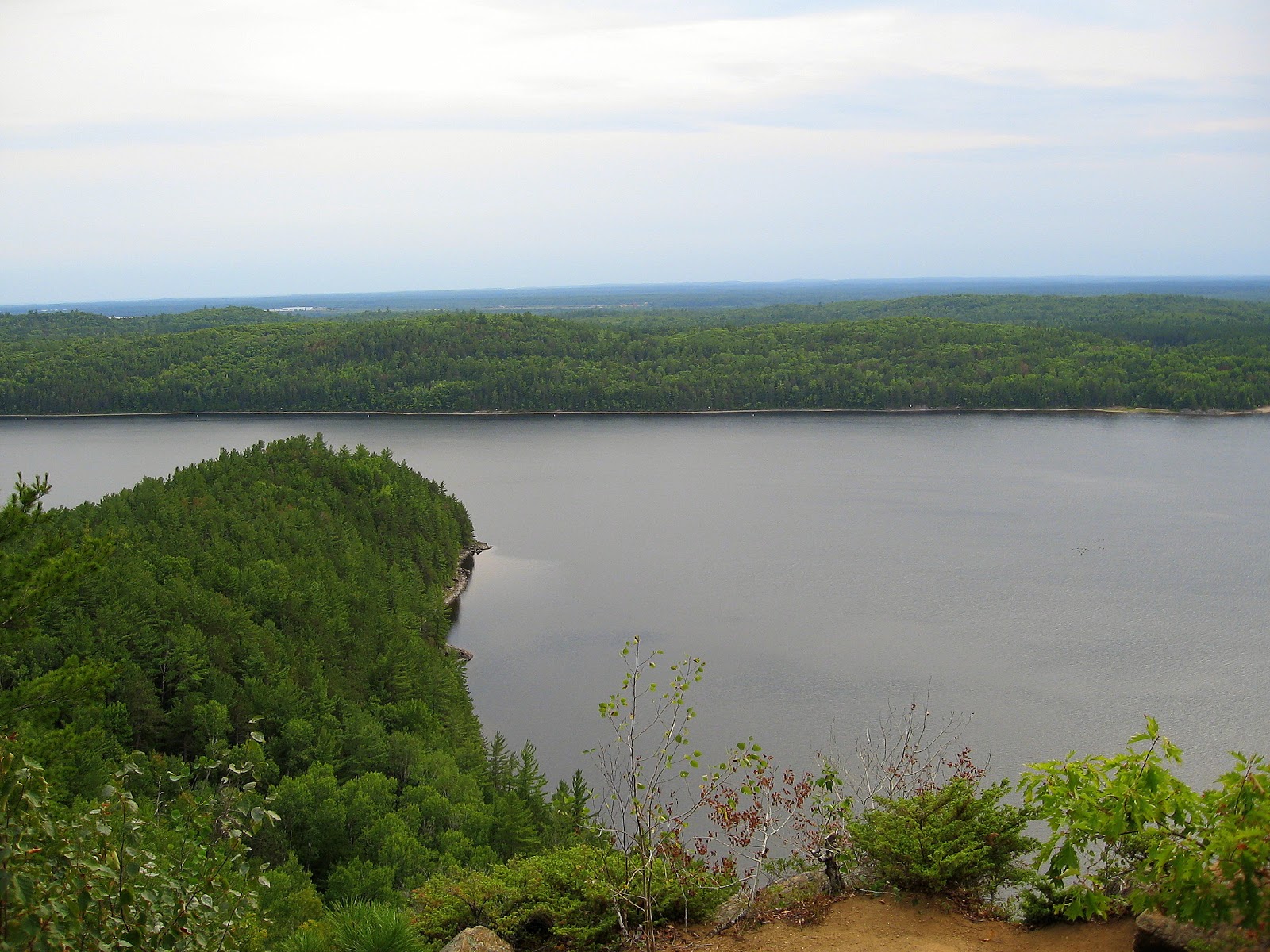
Weather changes quickly on Georgian Bay and by the time we had finished lunch the wind had picked up which made the crossing to Big McCoy a bit of a slog but definitely worth the effort as this is a really nice island to camp on and apparently it is also quite significant to native peoples of the area.   Each time I have visited Georgian Bay I am keenly aware of three things which are impressed upon me, texture, patterns and the solitude that is everywhere to be found.  You also get that "Big Sky Country" feeling with horizons that seem to bend to the earth's curvature. Like being under a dome.

Stark beauty


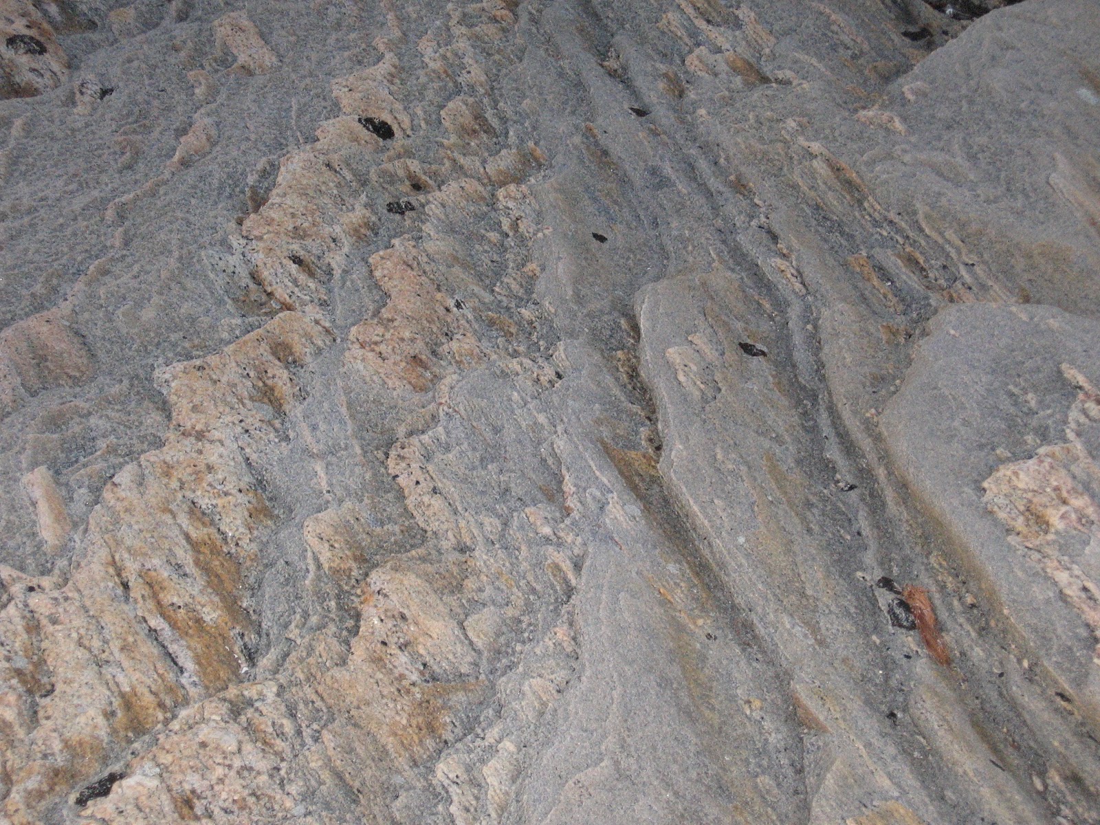
In rock or in the water

Big McCoy offers many campsites and we settled on one at the southern extremity which provided easy landing for our kayaks and where previous visitors had left several flat rocks set up that could be used as tables.  It also had that important amenity, the thunderbox!  Behind where we set up, in the trees was a large flat clearing that we think may have been used for meetings by native peoples.
Kitchen area
Parking on Big McCoy
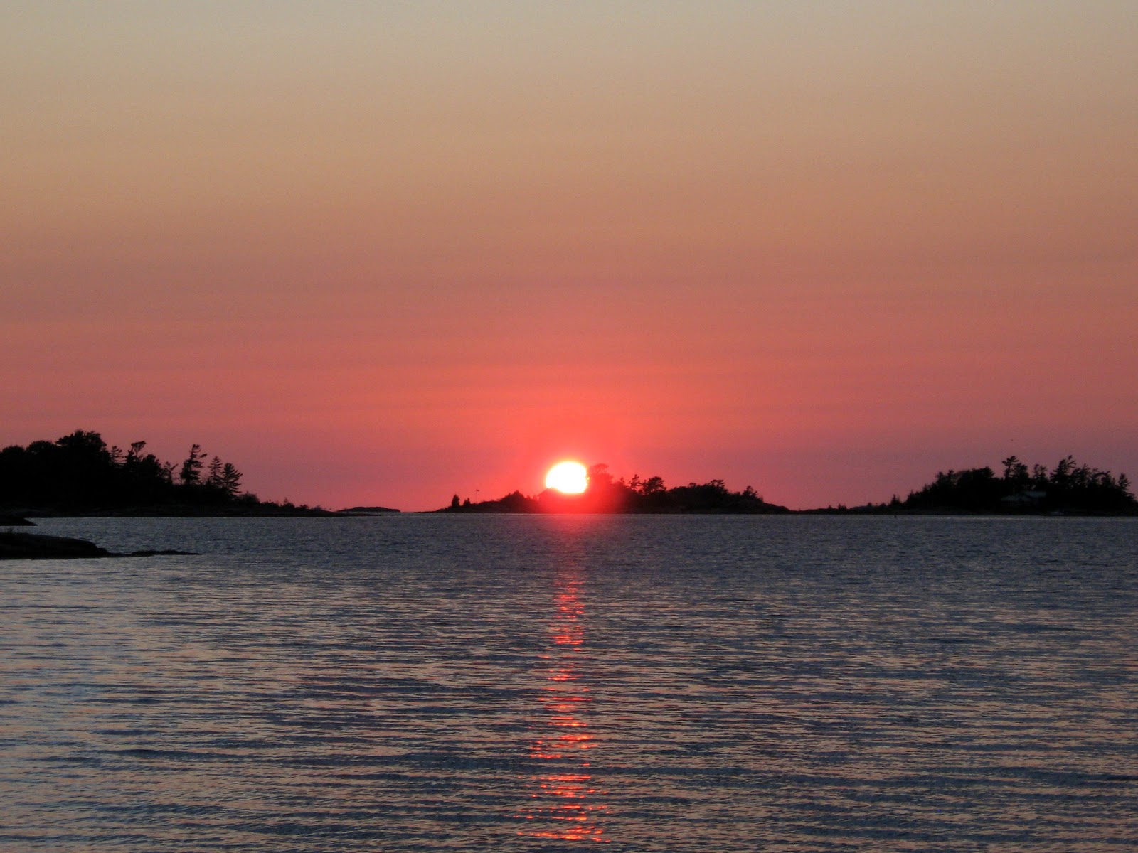
We had hoped to stay here two nights to allow exploration of The Limestone Islands about 5km to the west but weather forecast was predicting high winds beginning NW then changing to W so rather than risk being wind bound here we determined to head back towards north end of Franklin to find a sheltered camp that we could easily gain access to the Shebeshekong channel east of Franklin and so have sheltered passage back to Snug Harbour if winds stayed strong.   Our day on Big McCoy ended gloriously with a beautiful sunset which we sat and watched from a westerly facing rocky shore.
Sunset from Big McCoy

With high wind warnings forecast we felt it prudent to move on after only a one night stay on Big McCoy heading back to the north end of Franklin Island to look for another camp that would allow easy access to the inside channel between Franklin and the mainland and so be sheltered from the predicted west winds when paddling back to Snug Harbour.  After first stopping and checking out a site on King Island where we had lunch, we carried on to another site on a beach at the NE of Franklin Island.   This was a nice sheltered site although a little too close to civilization for my liking, cottages could be seen on the opposite shore.  This site had a sandy beach, a bit of a rarity in this area as well as a picnic table and yet another thunderbox. The wind could be heard high in the trees overnight but as we were in the lee of the island waters stayed calm.


Camp 3 NE Franklin Is.
The next day we toured around some of the islands staying to leeward so that we never had to deal with the brunt of the wind and waves coming from the west.   Checked some other campsites around where we stopped for lunch, found that some were now inaccessible from the water as channel entrance was too shallow requiring us to walk in from an adjacent channel.  Apparently water levels have been steadily dropping.   Once again we were rewarded with a beautiful sunset to end our fourth day of the trip.


Day five dawned overcast, blustery and with the rumble of thunder in the distance so we hurried to break camp as possible thunderstorms and rain were forecast.  A light shower began before we finished packing up but not enough to be of any concern and we set off on our final leg of the trip heading east then southeast into the shelter of the Shebeshekong channel enroute to Snug Harbour.

Author, image courtesy of Karl Parks 
The thunderstorm never materialized and the trip down Shebeshekong channel was uneventful until we reached Burritt Point where we turned west exiting the channel only to encounter strong westerly winds and high waves making a real struggle out of the last two kilometres before finally surfing east into Snug Harbour.   A great trip even if we didn't make it to all of our planned destinations but good reason to go back again in the future.

KayakJock
All images by author unless otherwise noted.


Wednesday 12 September 2012

Oiseau Rock-Ottawa River Paddle


September 7, a friend and I set out from Petawawa on a weekend kayak camping trip up the Ottawa River, our destination Oiseau Rock and perhaps Deep River depending on weather conditions which were not looking at all promising.  I had paddled the area before but had little time for exploration on the previous trip and this was the first time for my paddling companion so we were determined to make a go of it despite unfavourable weather predictions.

Petawawa Point

Oiseau Rock or bird rock as we would literally translate to English is a massive cliff (150 metres or 492 feet) looming over the Ottawa River just a few kilometres downstream from Chalk River nuclear facility and named bird rock by Algonquin Indian peoples to honour the Thunderbird held sacred by them and epitomised by the  Peregrine falcons which once nested there in significant numbers.

Weather was pleasant as we put in at Petawawa Point following the channel markers to reach deep water and avoiding the many shoals among the islands off Petawawa.
On return we tried a more direct approach but encountered shoals between Indian Pt. and Lilian Is. so would recommend staying with the channel even in a kayak.   It is only about 15.5 km to Oiseau Pt. where we planned to camp so we take our time and enjoy the scenery.   The east side of the river as you travel N or NW has shallow sloping shore that may extend for 200m offshore and at one point we ran aground on soft sand forcing us to get out and tow our kayaks about 50m further out to find deep enough water so I suggest taking a course that keeps the chain of islands; Pearl, Oak, Shoal,  Irving, Davis etc close, just off your starboard beam which will keep you in deeper water.  The west shore north of Petawawa to Chalk River is DND property and is posted so we decided to wait till Pointe Malin where there is a small islet with a navigation light just off the west shore where we could stop for lunch.  There is a channel between the islet (Deep River Islet) and the posted mainland which during times of high water may be navigable by a kayak.
Light on Deep R. Islet
Looking south from Deep R. islet

On arrival at Pt. a L'Oiseau we set up camp, I decided to opt for some shelter as the Saturday forecast was for 20km wind and rain.  We moved a picnic table to higher ground that we might set up some tarps.
My tent & our sheltered table

As the day was still nice we decided to take the hike to the top of Oiseau rock while the ground was still dry fearing Saturday's weather might make the trail too treacherous.
 trail up Oiseau Rock

Are we almost there?
Reaching the summit one is rewarded with a view that makes all that effort worthwhile, looking to left of image you can see Oiseau Pt. reaching out into the river, our camp being on the other side so hopefully protected from the NW winds expected Saturday.
Looking west
Looking NW or up river
From the lookout a short trail <100m runs NE to a tarn on top of the rock where there is a picnic table, where if you had the foresight to pack a lunch one could sit and enjoy a meal.
Tarn atop Oiseau Rock
The winds began during the night and Saturday dawned wet and blustery, wind although blowing down river, yet strong enough to eddy back into the bay to rattle our tents and shelter; not a day for paddling. 

 When it lets up somewhat in the afternoon we hike the lower trail to the lookout facing the cliff.  On examining the cliff face through binoculars I am greatly disappointed to see the extent of graffiti defacing the natural beauty of this timeless landmark and all but obliterating, or at least rendering them indistinguishable, the pictographs placed there by native peoples.  The interpretative sign tries but fails to guide the viewer past the etchings of imbeciles to the placement of the pictographs.  It almost seems as if some tried their best to obscure them by using a red paint similiar in pigment to that used by the native people.
Oiseau Rock from lower lookout

Graffiti

I think, that in my ideal world, that somehow by removing these mindless scrawls magically by the same act we could erase Sharon, Blayne, Scott, Rick and others of their ilk from the gene pool thereby safeguarding this heritage for future generations to enjoy. Hah...if only! 
Rainbow after the rain
Around 6:30p.m. skies clear again and we are presented with a rainbow which seems to indicate the pot of gold might only be a couple of kilometers offshore, hmm..
Sunday is a decent day, mostly cloudy with about 10k wind from NW so we will have a tail wind on our return journey.  We paddle round to get a close up of the cliff face from the water and the solitary chimney like rock created by glacial forces before turning about and heading downstream towards Petawawa.

150m/492'

Rock tower
We retrace our route back to Petawawa Point arriving at the beach around 4p.m. feeling satisfied that we had made the most of a less than ideal weather weekend and are a little more knowledgeable about the area.


Saturday 14 July 2012

Rideau Paddle Kingston Mills - Narrows

Aint this awesome camping weather!  Tuesday July 10, day 1, four of us started from Kingston Mills brandishing our transit pass’s as we headed up the canal towards Upper Brewers locks to spend our first night under the stars.   Not as early as we had hoped being first delayed by the bridge being up for boat traffic (of all the nerve!) keeping us from the parking area, then Mike and I having decided to launch in the basin, were told we would have to wait for another boat’s arrival before being locked through.  Peg and Yvan opted to launch on the Col. By lake side bypassing the lock.

We stopped at Green Island which appears to be a bird sanctuary judging by the number of Caspian terns and Cormorants roosting there, for lunch and a swim.  A little further up river is a picnic site that would have been better, table, grassy and shady but it was still an unknown then and it was the old bird in the hand….. etc. 

Green Island

A little refreshed we continued on, passing from River Styx into the narrow channel of the Cataraqui River and our first (for some) lock at Lower Brewers and a quick pit stop before continuing and ending our day at Upper Brewers. 

On arrival we met up with Roy who was paddling to Perth in an inflatable dingy and who had preceeded us from Kingston Mills where he had spent the night.  A word of warning; Kingston Mills is the worse place to camp due to the busy rail line almost on top of you, probably why it is on the other side of the River Styx: It’s Hell!
Upper Brewers has a nice easy landing with grassy banks and a low canoe/kayak dock and a very nice private area to camp.
 Upper Brewers camp

Day 2 and we head off around 9 a.m heading for Davis locks where we will have our second night’s camping.  A short distance upstream the channel opens into Cranberry Lake a very picturesque area of the waterway then it is past the bay leading to Seeley’s Bay foregoing the possibility of ice cream deciding instead to wait till lunch at Jones Falls.


After some narrow winding channels we reach Whitefish Lake and pass the channel to Morton Bay and Rock Dunder.   We head in for lunch and take out at the grassy area beside the Kenney Hotel just below the locks at Jones Falls.   Peg availed herself of some tasty take-out food and Yvan met up with some friends who cottage in the vicinity.

Jones Falls
After lunch we began our lock through which took approx an hour for the four locks and the 60’ lift.  Then it is just about 4km to go around Birch Is. And part of Sand Lake and we reach Davis locking through before taking out on the west side to set up camp.  A short time later we are joined by Roy who will also camp here.  We have late afternoon shade and will have early morning sun to dry up any dew overnight.
 View south from Davis Locks

Day 3, after a pleasant restful night we are off to Chaffey’s lock a mere 3km upstream enroute to the Narrows where we will end our trip.    
Chaffey’s was busy and we have to fit in with 5 cruisers which take up all available wall space so we hang on to their fenders and get a chance to chat with their friendly American crews.

Chaffey's Locks

Boathouse at Chaffey's

After Chaffey’s we bear right thru Indian Lake, an alternate route is to go left thru Benson and Mosquito lakes (longer but very pretty) thence across the narrow isthmus into Lake Newboro and north to Newboro where we plan to stop for lunch. 

Lake Newboro

  We lunch under a shady tree at the entrance to the locks then lock through what will be our last lock of the trip; this is one of the three automatic locks on the waterway and marks the head of the waterway so from now on it is all downhill and the navigation bouyage will be reversed.
Lunch spot at Newboro locks

From here on we just keep bearing right along the eastern shore of Upper Rideau Lake until we reach the Narrows locks where my vehicle is parked.  
On arrival at Narrows we land at the beach to the left of the locks where I load up my yak.   The others carry their boats across the road to leave them closer to the locks and within sight of the lock staff as they have to leave them while I ferry them back to Kingston Mills for their cars.   After dropping them off at Kingston Mills I headed to 401 and home feeling very satisfied with what once again was a great kayak camping experience.  And now that we have transit pass’s we’ll just have to do some more!

Narrows take-out