Saturday 11 October 2014

Thanksgiving Paddle and Hike to Rock Dunder

Rock Dunder

When autumn arrives in this part of the world; Ontario Canada, bringing those warm, sometimes startlingly clear sunny days to a landscape awash in vibrant colours, there is no better way (I think) of enjoying the great outdoors than paddling a kayak, except perhaps paddling a kayak and taking a hike in the woods as well.   This is something a group of us have been doing over the past number of years with a paddle and hike to Rock Dunder, usually on or about the Thanksgiving holiday choosing a time when weather is most suitable the better to enjoy natures extravaganza.


Rock Dunder near the village of Morton in Rideau Lakes Township is a hill of about 180 m (590 ft) elevation overlooking Morton Bay and Whitefish Lake, part of the Rideau Canal waterway. It is the highest point of land in the area affording marvelous views of the surrounding countryside, which at this time of year is ablaze with fall colours.   This will be our destination, the summit of Dunder where we will have our picnic lunch and enjoy the view.


Put-in by Old Kenney Hotel
On this occasion we are eight in number and our put-in will be upstream from Dunder at historic Jones Falls in front of the old Kenney Hotel.  Once a mile long set of rapids and falls graced this stretch of river, now replaced with a set of four locks with a lift of 18 m (60 ft) and a stone arch dam.  The dam had the distinction of being the largest in North America when it was completed in 1832.  Today a remnant of the falls trickles into the basin below the dam(below).
Remnant of falls

Launching off the grass by the Kenney Hotel we limbo under the Long Bridge built 1930's which connects the Kenney to the base of the locks and into the open water of Whitefish Lake for an approximately 6 km paddle to Morton Bay at the base of Rock Dunder.
Morton Bay
Entrance to Morton Bay


This will be a relatively short paddle but the hike, 2 km each way is fairly demanding over rough, sometimes quite steep terrain and the landing we use is not the easiest and will require a bit of time to lift eight kayaks up a steep embankment.  This site being difficult to access and somewhat removed from the trail leading to the summit provides some security for gear left here while hiking, although this has never been of great concern.                                                                 

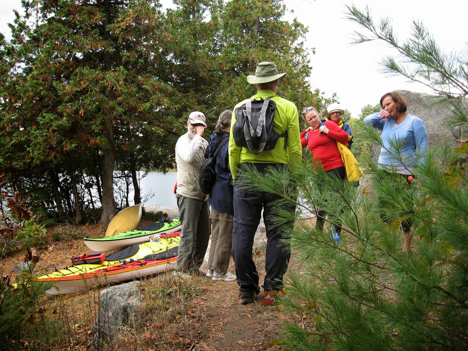
Parked and ready to hike
To begin the trail follows the shore of Morton Bay and is fairly level up to the first cabin where you could take shelter if needed.   Many ups and downs before crossing a small creek.   Then it is steadily uphill so it behooves one to equip themselves with sturdy footwear.   Being Thanksgiving the trail can get quite busy as I think many come to whet their appetite for the turkey dinner to come, or perhaps to work off an overindulgence of a past one.
Steeper

Creek crosses trail


With the summit within reach the trees fall away to reveal a 360 degree vista to the horizon.  To the SE one can make out the Skydome on Hill Island in the St. Lawrence River, a distance of about 27 km as the crow flies.  And below us the waters of Morton Bay leading to Whitefish Lake and the Rideau Canal. Everywhere the reds and golds of maple and birch with their showy finale before once again succumbing to another Canadian winter.


Morton Bay to Whitefish Lake beyond
Sitting atop Dunder we can enjoy lunch and the view, while contemplating what a wonderful resource we have in this Rideau Canal waterway of which today we have traveled just one small part of its 203 km length: truly a World Heritage.   Lunch over we retrace our path down the rock to our landing site to change back into paddling gear before paddling back to Jones Falls.  Then its a drive home for a date with a turkey, another happy Thanksgiving!


Happy Thanksgiving!
from
Doug

Thursday 31 July 2014

Thousand Islands Kayak Camping

Willowbank to Mallorytown Landing


Canada's 1000 Islands National Park situated as it is at the eastern end of Lake Ontario, sandwiched between New York state (U.S.) and Ontario (Canada) is a boaters paradise and is particularly attractive to those kayakers who enjoy kayak camping as the park maintains boat in campsites on most of the park islands, some are on a first come basis while others may be reserved.   Sites have access to composting toilets as well as being equipped with picnic tables and usually a shelter nearby where you could eat if inclement weather.  The months of July and August tend to be very busy so in this instance as I had particular sites I hoped to use I opted to reserve which adds an extra $11 to my fee.    This trip takes us almost end to end through the 1000 Islands missing a couple of park islands to the west, Milton and Cedar near Kingston and Stovin Island to the east, off Brockville.  Travelling with Karl a kayak buddy in my vehicle, we put-in from a marina a few kilometers west of Gananoque leaving my car there for the duration of our trip;  my wife will pick me up where we finish and drive me back to retrieve my vehicle.
Willowbank to Mallorytown Landing
Paddling SW from the marina brings us to the channel which separates Howe Island from the north shore of the St. Lawrence river which we follow east dodging the Howe Island ferry's cable to reach the Admiralty Islands close to Gananoque. This is one of the busiest spots on the river with tour boats and every variety of pleasure craft whizzing by with very few that will give kayaks any leeway.  Several of the  Admiralty Islands belong to the park, Beaurivage, Aubrey, Mermaid and MacDonald, all provide camping.   MacDonald has some sites with very easy landing at the SW end and is a good choice if you need to make a quick pit stop.   Passing south of Beaurivage we continue east around the north end of Bostwick Island, here if you are of a religious bent and feel the need to commune with the Great Spirit you can nip into Half Moon Bay tie up your yak to the hitching rail and participate in Sunday service alfresco; also a good spot to take out and have lunch!   Today being Sunday we decide to go on to Leek Island (also known as Thwartway Is.) another Park island, and land there to eat lunch and perhaps have a swim.
Pulpit, Half Moon Bay
I might add that a Beaching Permit is required in order to land on the various park islands and is good for a day.   Leek island is popular with many boaters as it has a nice shallow bay good for swimming and boaters anchor offshore so eschewing the requirement to purchase a permit.   So... it is rarely visited by park personnel and a couple of kayaks on the beach are likely to go unnoticed, good spot for lunch!   Leek Island has many power boats at anchor some blasting pop music and there is a general party atmosphere.    Just us on the beach having lunch until a raft of kayaks appear; rentals from 1000 Island Kayak in Gananoque.   These are young kids in their 20's out for a day trip and we swap stories with them before heading off to Camelot where we plan to camp the night.   Rounding the southern tip of Leek we head NE staying just inside Canadian waters which will take us to Camelot a stone throw from the U.S. Grindstone island.
Kayak landing Camelot Is.
Camelot is my favorite camping spot in the islands, being furthest away from the Canadian mainland it is not plagued by all the noisy little runabouts and Seadoos although frequently visited by larger tour boats it is generally quite peaceful and the campsite I booked in my opinion is one of the nicest to be had.  It is a larger site good for 2 tents, gets good sun and a lovely view.
site 1 Camelot
By climbing on the rock which encloses the southeast side of the site one can look across at Grindstone Island a mere 500 meters distant.  We were lucky to have chosen this day to visit as a notice informs us that the island will be closed to visitors from the following day as a controlled burn is planned to aid regeneration of Pitch pine.   The rest of the day I spend reading and enjoying a swim off the boaters dock just below our site.  There is a song about a place called Camelot extolling its extraordinary attributes perhaps they could add"and the mosquitoes are but very few and seldom do they chew".  The islands being exceedingly dry they just were not a problem!  Morning dawns sunny and perfect (hey its Camelot!) and after a leisurely breakfast of bacon and pancakes I'm ready to move on.
passing below our camp on Camelot
Leaving Camelot behind we travel NE more or less following the line of the Lake Fleet Islands which run SW to NE mid-channel passing Astounder, Sugar and Prince Regent islands to name a few.  I have a keen interest in birding but at this time of year there is not a great deal to see here from the kayak but some species to watch for are Common and Caspian terns an occasional Bonaparte gull, and the ubiquitous Ospreys.

Georgina Island route

Bonaparte gull
Caspian tern

Our next port of call will be Georgina island which lies directly beneath the Thousand Island or Ivy Lea Bridge and this is where we will be spending our second night.    Georgina is conveniently in the middle of our route distance wise which is why it has been chosen but I am not anticipating much in the way of peace and quiet.   We avail ourselves of all the neat little channels we find between islands, no great distance to cover so we can take our time to explore.   I plan to stop at the south end of Ash Island to have a look at  both   
the entrance to The Fiddlers Elbow and Lyndoch Island. The Fiddlers Elbow is a narrow channel reputed to have very strong currents and this proves to be the case as we can see the water roiling near the entrance, we will be going around the north shore of Ash so will be avoiding it. 
While doing a bit of research on the area I found a blogger who has determined that Lyndoch (or Lyndoe) island was once a hideout of the pirate William (Bill) Johnston in the mid 1800's.   The town of Alexandria Bay on the U.S. side of the river has for many a year obtained great mileage out of "Wild Bills "legend much of which is likely spin but there is no doubt that the Thousand Islands was his bailiwick .   Below is Lyndoch island which is also a park island but has no camping with Ash island to left, around the corner of Ash is the Fiddlers Elbow and in the distance is the 1000 island Skydeck.


Lyndoch Island

Georgina has only two campsites both of which are small and best suited for a single tent but one was booked so we squeeze both tents onto the leveled pad .   The areas designated as kayak landings are not great, one is but it is about 300 m away by rugged trail so we make a difficult landing near the closest boat dock and haul the kayaks over dead branches.   Lots of current around the island but we are in a bit of a cove beside the boat dock.   Traffic noise is constant and every little while a semi does an engine break plus there is a steady flow of boat traffic passing the island but hopefully after dark this will dissipate.  This bridge is the beginning of U.S. interstate 81 which takes you all the way to Tennessee a very busy north south highway.   As dusk falls the lights on the bridge begin to twinkle prettily and the boat traffic stops but the traffic above continues, you sort of get  used to it after awhile but I would not camp here again, opting for Mulcaster island instead about 7 km back the way we came.  Morning arrives and its going to be hot!  Today the plan is to stop at Rockport about 5 km distant where we can go ashore for a restaurant meal.  After a light meal we load up and head out taking our time as it is only an hour's paddle to Rockport which is a bustling little holiday village one of several access points for boat tours of the islands, with its restaurants doing a brisk trade feeding the busloads of tourists that are deposited there daily.   There is a nice grassy area to land just to the right of the church where we can leave our kayaks till we return from eating.  Three restaurants all under same management and one is serving breakfast until 11:00 and we can just make that.   Breakfast is a meal that I most enjoy in a restaurant and it is after 11:00 so it can be brunch.

Rockport 

Restaurant


Feeling quite replete after bacon eggs and my fill of coffee we are off on our last leg of the trip, paddling around Grenadier's east shore where we will be side by side with the ship channel traversed by the big lakers plying between the Great Lakes and the ports of the world.   Grenadier is yet another park island with camping and docking facilities at west, central and east.  If you are kayak camping Grenadier east is the best choice, just a couple of sites and very private the bay being shallow it is seldom visited by larger craft.  If you need to make a pit stop Grenadier central has facilities, this is the busiest camp ground and the shallow bay attracts a lot of power boats that anchor offshore to enjoy swimming.   As you proceed NE you pass Sister Island which is just inside U.S. waters and is easily recognized by the light keeper house. In the bay opposite you may notice a white plastic bottle which marks the site of a wreck some of its ribs still discernible when water calm.  At the NE end of Grenadier there is a sizable marsh which is fun to paddle through, there are two channels one quite obvious the other more easily located in spring before the reeds fill it in. From here we are just under 3 km from our destination Mallorytown Landing where we will end our trip.    


Please feel free to leave me a message or comment and if you are travelling to this country for kayaking and require further information drop me an email.

Doug


Sunday 13 July 2014

Kayaking the Ottawa River

Petawawa Point To Deep River

Green =day 1, Red=day 2, Yellow=day 3
The Ottawa River offers great kayaking for both flat water and white water as well as some magnificent scenery.   The area between Petawawa and Deep River is no exception and in addition has several sites suitable for camping and day use, being maintained by some sort of recreational organization probably from the two main communities, Petawawa and Deep River and likely in conjunction with the municipality of Pontiac (QC) in which the sites are located.   The Ontario side of the river in this region is DND property with no access to the public.   I have kayak camped this area a couple of times always in the fall but a kayak buddy expressed interest in kayaking the area so we planned a three day mid-week visit at the end of June before summer holidays kick in and everything gets rather busy.

The plan being put-in at Petawawa Point and paddle up to Oiseau Point the first day, a distance of 15 kilometers where we will camp overnight; it is a fairly long drive for me so we are looking at 10:30-11:00 as a likely put-in which still allows for a leisurely paddle and time to do something on arrival late afternoon.   We have wonderful weather for the trip, mid to high 20's unlike my last visit here when we had some serious rain and wind.
Sandy cove for lunch stop
After travelling about 4 km we stop in a sheltered sandy cove to have lunch. One of the attractions of the area is the many sandy beaches to be found, so different from the river near Ottawa where shale is far more likely.  A perfect day for paddling, the sun has come out finally after Tuesday's torrential downpours which had even caused flooding in some areas around Ottawa.  Lunch over we're back on the water and passing a string of islands that are offshore from Fort William Quèbec and we have brilliant sunshine with just a few fair weather cumulus. Water levels are much higher than on my previous visits in fall when it was necessary to stay a long way from the Quèbec shore to avoid running aground. Before long we are approaching the big bend in the river where there is a small island with a navigation light very close to the Ontario shore.

Islands off Ft. William
From the light it is only another three kilometers to Oiseau Point where we will camp for the night.  This is a lovely little campsite on a sandy beach on the lee side of Oiseau Point just around the bend from Oiseau Rock which towers almost 150 meters above the river.     The site is furnished with some picnic tables as well as outhouse style toilets and secure garbage depositories.  So no excuses, pick up before you leave!   I am not going to say too much about Oiseau Rock itself as I covered this in a previous blog which you can find elsewhere on these pages.  My fellow paddler is a hiker and was keen to see the view from the top so as we have plenty of time before dinner we head up the trail having ditched our paddle shoes in favour of running shoes, the trail is quite steep in places and in one location a knotted rope is strung to aid in the climb.   Worth the effort as the view from atop is magnificent, see image below.


View from Oiseau Rock
Oiseau Point lies below, our camp being on the left or downstream side of point.  My friend chose to camp on the beach, I found a level pad just under the trees.
Next morning we continue our trip upstream towards Deep River first stopping to view and photograph the rock from the water, an impressive sight for sure.


Oiseau Rock
This to me is the nicest part of the trip, almost no cottages and we are midway between the communities of Petawawa and Deep River so not seeing any traffic so just tranquility, a chance to imagine the river as it would have been like for our indigenous people and the early settlers.  We are very fortunate to have sightings of both Red-tailed hawks and an adult Bald eagle and with the quiet I am able to identify the calls of several songbirds as we paddle along.  We make one more pit stop at yet another sandy cove eschewing lunch until our arrival at Schyan River where we plan to have our last night's camp.  Here we will be almost across from Deep River on Ontario side and within sight of Mt. Martin on the Quèbec side.
Sandy cove pit-stop
Schyan River camp


The Schyan River tumbles out on a shallow sandy delta on the north side of Schyan Point, there has been a couple of picnic tables set up as well as an outhouse so again camping is quite comfortable except for the mosquitoes .  This is likely because the river spawns vernal pools which then become stagnant and provide ideal breeding grounds.  Even mid-day in brilliant and hot sun they were ravenous.  The Schyan is shallow, rocky bottomed and the colour of Coca Cola it probably slows to a trickle later in the year.

Dusk at Schyan River camp
Schyan River estuary

The approach to Schyan River is very shallow and mostly sandy bottomed, and we had left our kayaks on the beach with sterns maybe a few feet from waters edge but by morning they were now about 20-25' from the nearest water forcing us to walk them along the beach to find a spot with enough depth to float them off when they were loaded.  We noticed a similar phenomenon at Oiseau Point although not as drastic when the net bag I had left tethered to a rock to cool my flask was found high and dry in the morning.   The conclusion being they let water out of the hydro dams down river during the night.  There is no shortage of driftwood at this site so we built a nice fire regardless of how hot the night to try to keep the bugs at bay, they won so an early night!

Next morning and the promise of yet another scorcher of a day, blue skies with a few puffy white clouds and no wind to speak of.  A leisurely breakfast before breaking camp and stowing the gear back in our boats.   We will kayak back to Petawawa in one day this time a distance of almost 30 kms with a stop for lunch, probably at the camp on Oiseau Point as it is about the half way mark and has facilities.

It is very hot and still as we paddle downstream, this time staying closer to the west shore, the opposite of our upstream paddle.  We have seen a number of common Mergansers, some with their little brood of bathtub duckies skimming along behind, we even had one of these little guys approach our camp yelling something like; help me I'm lost! We believe that one did eventually find it's siblings.   The scenery here is in such contrast to that which we have in the lower reaches of the river around Ottawa, I think majestic is perhaps the best adjective to describe it.
Looking south towards Chalk River
Oiseau Rock from the north
Today is Friday the start of a long weekend and as we get closer to Petawawa there is a marked increase in boat traffic with its accompanying noise and the solitude bubble pops. And thoughts of Voyageurs and Indians in Birch bark canoes now dissolve only to be replaced by the mundane: Should I stop at McDonald's before driving home?   The beach at Petawawa Pt. is crawling with people enjoying the sun, picnicking swimming and having fun as we come ashore to load up our boats before changing to some clean clothes then heading for home.  Happy to have had this quiet interlude to recharge our batteries!