Wednesday 16 November 2016

Lyndhurst to Red Horse Lake

 Lyndhurst to Red Horse Lake - Squaw Island - 18.1 km

Squaw Island
This is a very pretty paddle and one I generally reserve for late fall probably just because it is so peaceful and with the sun traversing a lower ecliptic at that time of year one experiences some quite dramatic reflections which can make for interesting photos.  November 15, and we get yet another perfect day for paddling with a high of 13 c promised.   I find this time of year when heading out alone that I am in no great rush to get moving in the morning; dark and usually cold in the mornings I tend to linger with coffee and my ebook so that by the time I get to my launch it has usually warmed up some.  

Lyndhurst Lake
Today I launch from Lyndhurst public dock which has already  been dragged out and now sits on shore.   From here it is less than one kilometer to the entrance of Lyndhurst Creek which leads to Singleton Lake.
Creek
Red Horse Lake Rd.


Singleton Lake

There are a few dwellings along the first part of the creek on the west side, some year round, some just cottages.  Singleton flows out on the east side as the creek continues.  Here we have some sharp bends and there is now a house built at this scenic spot and just past here I sight the first wildlife, a Red-tail hawk.


Another kilometer and the creek flows into the Long Reach, a long narrow body of water considered part of Red Horse lake.
Bend to Long Reach
Long Reach
Now travelling NE, the Long Reach terminates at a narrows beyond which is Red Horse lake proper which is my destination today.  Historically I have always landed at the start of the portage from Red Horse to Charleston Lake (see hiker symbol on map) but today a picnic table on a small island catches my eye, no habitation or signs saying private so I decide this will do very nicely for lunch.  Turns out this is Squaw island and in addition to the table there is a fire ring; this would be a very nice campsite!

Squaw Island
Lunch
This works out well as it shaves a kilometer off each direction, having had a late start I'm monitoring my time to make sure I take out before dusk.  If one continues across Red Horse and turns right you can paddle all the way to Gananoque and the St. Lawrence river this being an ancient canoe route that served our indigenous people.  I may do this someday and I have previously paddled about half way, on that occasion taking out at Marble Rock after the first of the two portages necessary to reach the St Lawrence.   Lunch over I retrace my route, on the Long Reach I catch a glimmer at some distance from ruffled water on the otherwise flat calm.  With the binoculars I can determine that it was a kayak crossing and heading back into Lyndhurst creek, first and only sign of life today.  As I mentioned reflections can be quite dramatic this time of year and if viewed differently can create something almost mystical.

Lyndhurst Lake

Spirits in nature?


It is around 4 p.m. I arrive back at the put-in and the sun is setting as I pack up my gear for the drive home, about one hour and fifteen minutes.  Along the way I watch as the sun disappears setting fire to the western sky ending another great day on the water.


KayakJock

Friday 4 November 2016

1000 Islands New York State

Grindstone Is. - U.S. Thousand Islands

Click on any image to see full size!

November already, and the weather of late has been rather crappy, perhaps foreshadowing the possibility of a harsh winter to come. The temperatures have been running much lower than the norm, so when they predicted a high of 17 c for November 2nd it was a no brainer, get out and paddle as it might be my last chance this season as I need to knuckle down and get some work done at home.

I have done much paddling in the 1000 Islands but only briefly traversed u.s. waters (see my Boldt Castle post) so have had it in mind to make a circumnavigation of Grindstone one of the largest islands belonging to New York state and this seemed like an ideal time to do just that.

Grindstone Island

As forecast, the morning was mild but overcast as I load up the car, but by the time I reached 1000 island parkway the sun was shining and it promised to be a glorious day.  The plan is to circle anti-clockwise as wind from SW changing to W; so into it at the start but later it should be more help than hindrance.  Also I plan to stop for lunch at Thwartway Island before entering u.s. waters.

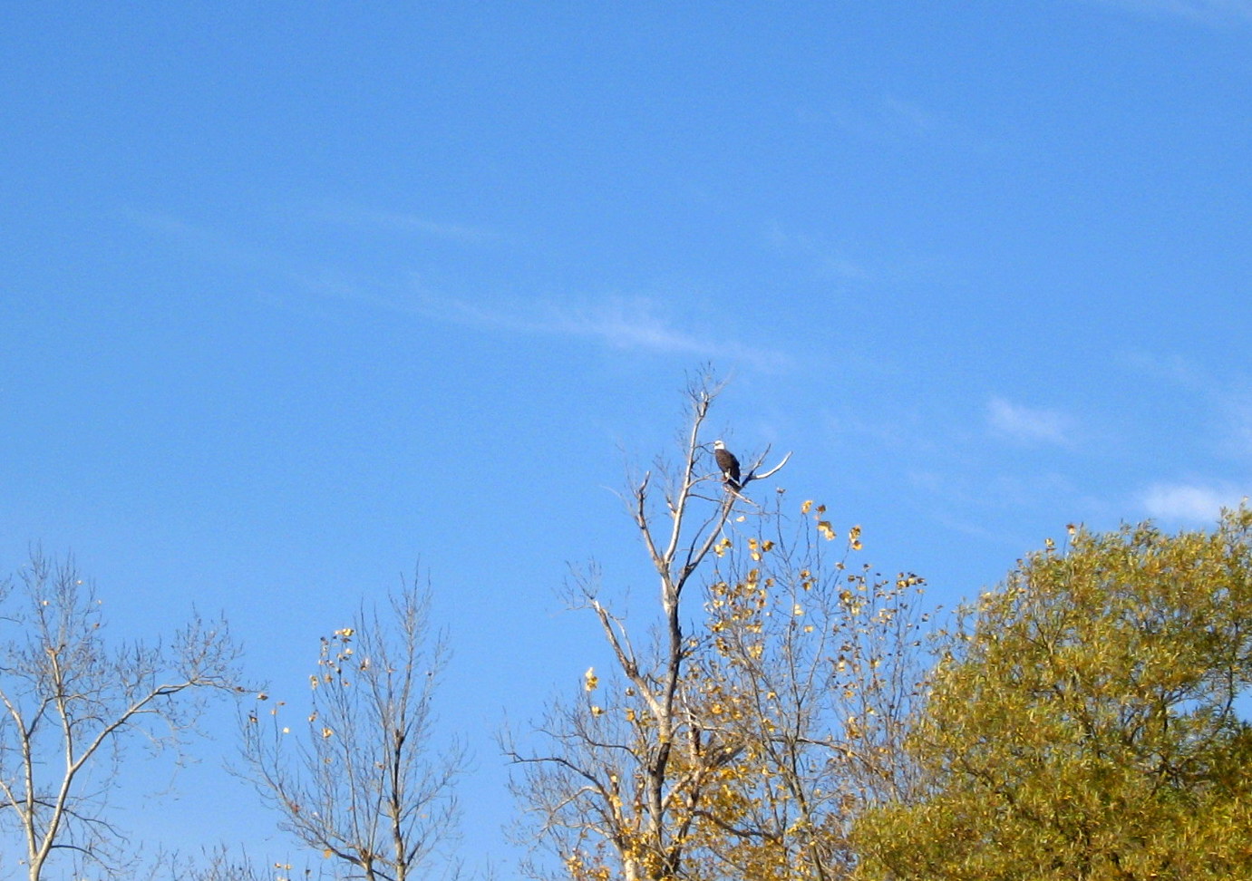
Launching a few kilometers east of Gananoque at 11:00 my first waypoint will be Corn island where from a distance I can spot a large raptor atop a tree.  This proves to be an adult Bald eagle.   


Put-in

Bald eagle on Corn Is.

I head SW into the wind which is close to the prediction of 9-10 km so very pleasant and I make landfall at the Parks Canada kayak landing in the bay on the SE side of Thwartway (aka Leek Is.) at lunchtime.   These waters are so peaceful now compared to the summer season when they would be just humming with Sea-Doos and a variety of power boats.  Today I have seen two small run-abouts quietly engaged in fishing.   The bay is sheltered from the wind so shirt off and catch a few rays while sitting on the dock to have my lunch.

Lunch on dock
Thwartway


Lunch over I paddle south into u.s. waters swapping over the map in my GPS to a NY topo obtained from the web.  Skies suddenly become overcast with high stratus creating that "calm before the storm" feeling which proved to be unjustified as within an hour it was back to sunny skies.
NW Grindstone Is.

Near Cummings Pt.

Rounding the SW corner of Grindstone the town of Clayton N.Y. appears in the distance.   I have never been there but for a small town it has some interesting attractions.  It is home to the Antique Boat Museum as well as an historical opera house.   I know the museum houses some fast boats once owned by Frederick Bourne, builder of Singer Castle down river opposite Mallorytown Landing.  On an island between Grindstone and the mainland I spot what I first thought might be a Martello tower similar to the one on Cedar island which was built by the British to defend Kingston.   Wrong! Just some fancy real estate.

Clayton N.Y.
The tower


Grindstone appears to be low laying and fairly sparsely populated, the real estate generally not on a par with what you find in the Admiralty Islands off Gananoque; nothing of great interest!    As I continue NE I pass first a laker going upstream then my second small flock today of White-wing scoters which come to the Great Lakes to winter, and I think at least one Black scoter.

Laker

White-wing scoters
From here I enter the channel between Grindstone and Picton islands to work my way up the eastern shore thence back to Canadian waters.  I had thought the tour boat season over so was surprised to see a pontoon boat belonging to Clayton Island Tours come chugging past with about half a dozen passengers. Travelling at a sedate pace, so not a bad way to see the islands for those who can't do it under their own steam.

Picton Is. channel
Clayton Tours


A small strip of land along the east shore is a state park which appears to be for day use only, with docking facilities but no camping or overnight boat mooring.  At about this point I am stopped watching two mute swans fly overhead and taking photos when I hear a powerful motor coming up the channel behind me.  Prepare to repel boarders!  I am being apprehended by a U.S. Border patrol.

Picnic Point State Park

U.S. Border Patrol
Their vessel pulls along side me and three of them step out of the cabin, I was still brandishing a paddle you see, or I might have made a dash for it... Citizenship? Where have you come from? Have you landed anywhere?  I.D.? Yes sir, in a little black barrel in that hatch back there if you care to dig it out! Did you see such and such islands along the way (trick questions). They decided to forgo trying to open the hatch, its a bit of a monkey puzzle for first timers and decide to look up my name, d.o.b. and I tell them I was last in U.S. last week with the cats at the vet (read setting up my drop).   Satisfied I wasn't a mule for the cartel they wished me Bon voyage and enjoy the rest of your day! It was all quite amusing although they are quite serious, they were very polite and hey, no shots were fired!

From here I'm about 6 km back to my put-in, about 1 km to Canadian waters. Squeezing first between Prince Rupert and Sugar islands, then Squaw before skimming past Gordon, one of the Canada Parks islands.

Downstream: a dead calm

Prince Rupert Is.

Kayak heaven!

It's 16:40 and I am back where I started after a very enjoyable paddle, almost 27 and a half kilometers in perfect fall weather and now a pleasant drive along the 1000 islands parkway before taking 401 home.


Psst, wanna buy some ganja? Fresh off de boat mon!


Happy paddling!
Doug

Wednesday 27 July 2016

Crotch Lake Kayak Camping

Crotch Lake - North Frontenac

Note: All images can be seen larger by clicking on them.

Crotch Lake on the Canadian Shield, is situated in and administered by, the township of North Frontenac; providing both kayak or canoe enthusiast with truly wilderness camping opportunities.   The lake is fed by both the Mississippi River and Gull Creek and drains back to the Mississippi which connects with the Ottawa River forming a long established canoe route of many portages.

Crotch Lake
I have camped here on many occasions over the years and this July a friend and I returned for a two night stay.   The lake can be accessed from either the north or south end; I have habitually used the southern one off the Ardoch road and only about a twenty minute drive from highway 7 at Sharbot Lake.  It is worth noting that due to the fact this lake drains to the Mississippi and subsequently the Ottawa, water levels appear to be under the control of Ontario Hydro which regulate this system to maximize its usefulness for hydro-electric power generation.   The result of this is that water levels change drastically through the summer-fall seasons which changes the topography of the shoreline in a less than desirable way, at least from a paddler's viewpoint.   

Southern access
In spring, May-June water is likely at the high water mark which maximizes the area that can be paddled, giving access to some very pretty back-waters such as the waterfall at Gull Creek as seen below in May, also Fawn Lake and Twin Islands Lakes can be paddled with the possibility of camping also.

Falls on Gull Creek
I have camped (site 63) in this area early July, but this trip the last week of July water was so low none of this was accessible.  Probably a good idea to ascertain water levels before choosing a campsite.

Old trapper's cabin
 
Camp July 2016


Some sites which in spring can be paddled right up to, may at low water be surrounded by rocks making loading/unloading a kayak more problematic.  It is still a beautiful lake to paddle throughout the season and for the most part it is quiet with most power boat traffic of the fishing variety.

From Twin-Island Lake
At the north end of Crotch the Mississippi river tumbles into the lake at Whitefish rapids, at high water you can usually paddle over the first set (below) and reach the second.  There are three or four campsites along the river bank here but at low water they are cut off from the lake except by portage.

Whitefish Rapids (lower)
This trip we had perfect camping weather; hot sunny days and warm nights with water just the right temperature for swimming, which we did as our site had a nice rocky ledge over deep water.  And of course facing west some lovely sunsets.
Sunset
Another thing that happens with low water which can be beneficial is that a number of sandy beaches and grassy areas will appear which can make for great places to go ashore for lunch and as can be seen below, provide lunch spots for some of the permanent denizens of the area.

White-tailed deer


Happy paddling from KayakJock


Thursday 14 July 2016

Day Paddles

Day Paddles


This is a new section where I will from time to time provide what I hope will be some useful information on what I consider day paddles in and around that portion of Canada lying within a radius of roughly 150 km of Ottawa, Ontario. These are in no particular order, but will appear more or less by whim or perhaps because I have just paddled yet again.  Distance shown is as I recorded but of course will vary by route you take so just a guide.

1. Kemptville Creek - Curry Park to Rideau River - 10 km

This is a short paddle that I pretty much reserve for those days when I have little time and it has the advantage of being only a 15 minute drive from home and this time was to be the last paddle of the season for me as my yak goes into storage this coming week and Saturday looked very much to be the last decent day in the foreseeable future.  Initially my plan had been to paddle Kemptville to Burritts Rapids had time permit, but Saturdays being what they usually are, shopping etc I almost ran out of paddle time completely and was debating whether worth going at all.  So launching at 3:30 the best I could hope for was down the creek and back likely with the last of this in the dark.


For others contemplating this paddle I might add that this can be extended to a decent day's paddle with possible destinations like Baxter Conservation (appx. 20km) or Muldoon Rd towards Burritts Rapids also about 20 km round trip.  This time of year no one else is out and water levels are down yet again.  Where does all our water go this time of year?  The Rideau, St. Lawrence and Ottawa rivers and just about every lake and stream around get the plug pulled!  I think it is the damn yanks siphoning it off to water their golf courses in Nevada!  Never mind building a wall, we need to build some dams!!


The sun had set by the time I reached the Rideau and had stopped mid-stream to capture an image so I knew I would be paddling some of the way in the dark.  I notice my GPS go dark all of a sudden, why you ask do I need to use a GPS on a creek.   Well I just try to follow as close as I can my outbound track hoping this way to avoid rocks or shallows I happily missed on the way down.  Clever little gadget had switched to night colours which are almost invisible using the marine profile.  Rather than fuss with it I just hit the click stick once in a while to activate the screen for a few seconds viewing.  Being mostly overcast it gets really dark in places but there are a few cottages and as I get close to hwy 43 bridge a house is ablaze with coloured lights, Christmas came early to Kemptville.

Navigation lights?
Excuse the image, I was still moving when I tried to take it.  Till next year!


2.
Big Rideau Lake - Narrows Locks to Colonel By island.  15.5 km

Narrows Locks provide easy launching for kayaks for either east or west travel on Big Rideau as well as adequate parking and washroom facilities.  Col By island is maintained by Parks Canada and is considered part of the Rideau Canal Waterway.

Narrows put-in
Col By Island


View from Col. By Island

Boaters travelling the canal can camp here for same rate as charged at locks and washroom facilities are available.  Note, take any garbage you have with you when you leave the island.


Narrows to Colonel By

3.
Big Rideau Lake - Narrows Locks to Westport 16.5 km


Looking west from Narrows
There is a gravel beach almost next to overflow parking lot for Narrows on west shore of isthmus providing easy launch.  Travelling west following north shore of Big Rideau will bring you to Westport a picturesque village and tourist attraction at the western extremity of Big Rideau.   Several restaurants, some doing take-out make for a pleasant interlude before paddling back.


Narrows to Westport

4.
St. Lawrence River - Singer Castle - Grenadier - Rockport 28.5 km

For this paddle the ideal launch site is Parks Canada facility at Mallorytown Landing, just off the Thousand Islands Parkway at the junction of County road 5.
Singer Castle - Grenadier - Rockport
Singer Castle on Dark Island, was built in 1905 by Frederick Bourne, one time president of Singer Sewing Machine Co. and today is open to visitors via tours out of Alexandria Bay NY. Like Boldt Castle this is a very impressive edifice and well worth the trip.   Dark isle lies about 4 km east of Mallorytown Landing in U.S. waters so that is our primary destination before heading SW along the outer shores of Grenadier island.

Dark Isle
Singer Castle


Singer Castle
Travelling SW you come to Peel, the first of a string of small islands running NE of Grenadier island, bearing a little more left you should pass Grenadier's most easterly point and thence follow Grenadier SW till reaching its end.  Sister island with its lighthouse will be noticed to your left, almost marking the international border it is in fact just inside u.s. waters.   The bay to your right has a sunken wreck of unknown provenance which may be marked by a plastic float. On calm bright days some of the timbers are still visible.

Peel island
Sister 


As the shipping channel is just beyond Sister island you may get lucky and get a little surfing from the wake of a passing freighter.

3G Maquiss
Passing Grenadier West and heading WSW will take you past Little Grenadier, Doctor, and Tar island on your way into Rockport where you can land on the grassy slope between the church and Boathouse restaurant.  If you can secure a seat on the deck at the Boathouse you will have a view of your parked kayaks. Three restaurants all very busy during the summer season servicing the thousands of tourists bused in for boat tours of Boldt castle and the Thousand Islands.
Boathouse Restaurant
Paddling into Rockport at the height of the summer season can be a bit unnerving as it is a high traffic area with power boats of all types zooming around you and on windy days the geography of the islands combined with wakes can make for very confusing water.  Taking the innermost channel through Tar Island Narrows is your quickest way out of this busy area and shortest return route to Mallorytown Landing.

O'Neil island
5. Charleston -  Charleston Lake -Charleston to Bill Island 17.5 km


Charleston Lake

The village of Charleston is the north access for Charleston Lake and during the summer season becomes a very busy place particularly on weekends but you should be able to find parking near the boat ramp at the west end of Water street.  This is a large lake with many cottages on numerous islands but is also home to Charleston Provincial Park which occupies a large area to the west and south affording a beautiful wilderness area.  I often head for Bill island at the north end of Donaldson arm by a variety of routes of varied distance.  This small island belongs to the park so I stop here to lunch and maybe a swim. A quieter area with few cottages.


Donaldson Arm from Bill island
There is also a nice beach in Sand Bay at the county park in the NE corner of the lake, about a 3.5km paddle from put-in.  It can also be reached by co-rd 39.  Access to the Provincial Park is at the south end of Charleston Lake off co-rd 3.

Charleston Lake
6. Rideau Lakes Township - Morton to Delta - Lower Beverly Lake - 24 km


The village of Morton is reached by highway 15 from Smiths Falls and there is a canoe/kayak dock on Morton creek just off the highway beyond the bridge.  You can park along the mowed verge.  This access is provided on private land so be respectful. 
   
Put-in
Morton creek


Morton creek meanders almost five and a half kilometers before reaching the lower SW extremity of Lower Beverly lake.  A very pretty paddle through a mix of farmland and deciduous woodland with a few cottages closer to highway 15. Then almost another 5 km up the SW arm before reaching the main body of Lower Beverly.


Delta creek
From here it is another 2 km across to the east shore where you can enter Delta creek which leads to the picturesque village of Delta with its historic mill once powered by the waters of Delta creek flowing from Upper to Lower Beverly Lake.  Here you can find a public launch where you can take out and have lunch.
Delta public ramp


From Lower Beverly to Delta is approximately 1 km up Delta creek which has a township campground on it's north side and houses on the other.  A little beyond the public ramp is the mill race and dam, thereby access to Upper Beverly would require a portage.